1. Ensure that the following network objects are defined:
2. On the Network objects toolbar, click Conflict Areas.
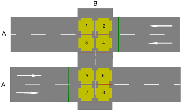
Vissim creates passive conflict areas in the two opposite directions of pedestrian links. Passive conflict areas are marked yellow by default.
The figure shows a modeling example:
3. Repeat the following steps until the desired priority rule is shown.
4. Right-click the desired conflict area.
5. From the shortcut menu, choose the desired entry:
Conflict areas on a link for pedestrians always have the same priority rule: pedestrians have the right of way or must give the right of way. Based on the current priority rule and the current speed as well as desired speed, pedestrians and vehicles decide when they can pass a conflict area.
A conflict area has a stop line distance. The stop line distance describes the upstream position on the link at which the pedestrians or vehicles have to wait if they have to grant the right of way. At a default value of NULL, the stop line position in the direction of travel is immediately before the start of the conflict area. You can position the stop line upstream from the regular stop line of the conflict area.
|
|
Note: If the two links intersect at an acute angle, the distance for crossing the road is greater. This also increases the time required by pedestrians to cross the link. Since there is no geometric analysis of the relative position of the two links related by the conflict area, a pedestrian may not have yet left the lane when he reaches the next vehicle. |
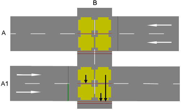
Pedestrians who want to cross the vehicle link (A1) and enter the conflict area on the left lanes of (A1) in the figure above have to consider the minimum speed that is calculated on the stop lines where the arrows end.
Minimum speeds are calculated dynamically at stop lines: pedestrians using minimum speed or a higher speed can pass the stop line, but other pedestrians have to wait before the stop line.
Pedestrians enter a conflict area with a vehicle link only if they can cross the entire link (in stages) so that they never are on a lane on which a vehicle is just passing through the conflict area. The desired speed of the pedestrian and the current speed of the vehicle are assumed here. Vehicles that are not yet in the network are not taken into account here. Vehicles that are more than 75 m times the number of lanes of the link from the conflict area are also not taken into account. This condition can no longer be fulfilled after entering the conflict area if, for example, a vehicle accelerates or enters the network at a relatively short distance. In this case, the pedestrian waits before the first lane of the vehicle link which he probably cannot cross completely before the arrival of the vehicle.
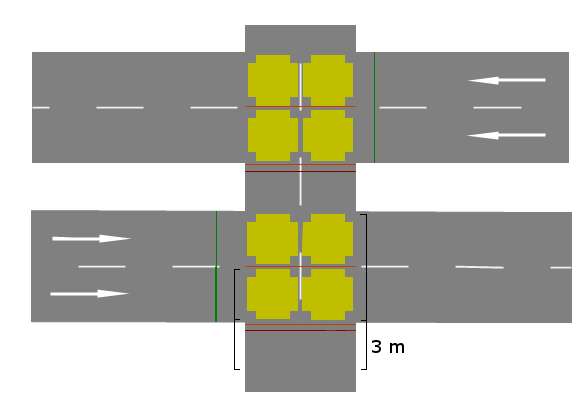
On the pedestrian link, the area 3 m upstream from the conflict area to the start of the conflict area is used as a "detector area" for the pedestrians approaching the conflict area (Modeling detectors for pedestrians). Pedestrians within the conflict area are always taken into account:
If no pedestrian is expected to enter the conflict area, the gaps between pedestrians or groups of pedestrians are transferred to the approaching vehicles. Thus they can respond accordingly.
Superordinate topic:
