Zones (also traffic cells) are the origins and destinations of movements (demand). This means that each trip starts in a zone and ends in another zone. Zones connect the transport supply (network model with nodes, links, PuT lines, etc.) and the travel demand (in the form of demand matrices (Matrices)), which contain the demand (trips) of all OD pairs of the model.
Every zone can be assigned a zone boundary (zone polygon) which represents the spatial extension of the zone. In the network model, zones are reduced to a zone centroid. Here the trips of a demand matrix are fed into the network. Every zone must be connected via a connector (OD pairs) to at least one node. The optional zone polygon has no influence on the calculation results in the assignment; however, typical GIS functions such as intersecting can be realized with the zone polygon (Intersect). Multiple zones can also be combined to a main zone for evaluation purposes.
The zone size can vary depending on the level of detail of the model. Zones generally describe the position of places or utilities (for example, residential areas, work places, shopping centers, schools). Structural data such as the number of inhabitants, the number of jobs or the number of school places are stored here, which are used for calculating the traffic demand as input data (Demand modeling procedures).
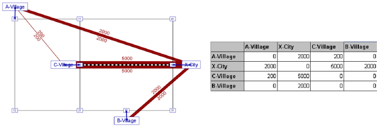
The Image 8 shows an example of the transport demand between the zones and how they are available in the demand matrix.

Image 8: Transportation demand between zones illustrated in the transport network and as a demand matrix
|
Note: Zone boundaries are managed (The surface data model in Visum) like surfaces and can consist of multi-face polygons and polygons with holes. |

